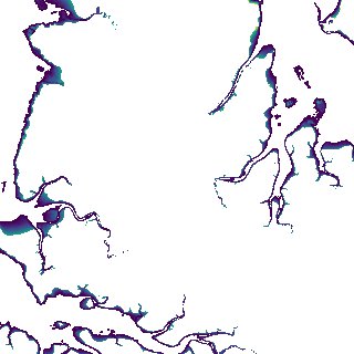
ga_s2ls_intertidal_cyear_3_x133y174_2017--P1Y_final.stac-item
dataset of product ga_s2ls_intertidal_cyear_3
Indexed by odc_admin
,
created
Region
x133y174
for
1st January 2017
Fields 🔗
creation_time
2024-03-28 08:23:18
dataset_maturity
final
eo_gsd
10.0
format
GeoTIFF
id
ee5b3a77-9193-48d9-8162-347df8c61393
instrument
ETM_OLI_TIRS_MSI
intertidal_hat
3.23
intertidal_hot
1.97
intertidal_lat
-3.8
intertidal_lot
-2.98
intertidal_offset_high
17.91
intertidal_offset_low
11.62
intertidal_otr
4.95
intertidal_spread
70.47
intertidal_tr
7.03
intertidal_tr_class
macrotidal
label
•
lat
-12.729 to -12.431
lon
130.551 to 130.844
platform
landsat-7,landsat-8,sentinel-2a,sentinel-2b
product_family
intertidal
region_code
x133y174
time
2017-01-01 00:00:00 to 2017-12-31 23:59:59